As part of our training to hike to the top of Mt. Whitney in 2015, we climbed Mt. San Gorgonio via the Vivian Creek Trail. Myself and two buddies from work, Bryan and Dustin, made the climb the two weekends before the Lake Fire broke out in that area. A hike to the summit of Mt. San Gorgonio, via the Vivian Creek Trail, is one of Southern California's monster hikes and is great for training for a Mt. Whitney climb. Mt. San Gorgonio, at an elevation of 11,502 feet, is the tallest peak in Southern California and is a must do hike for any Southern California Hiker.
Directions to Trailhead: To get to the Vivian Creek Trailhead, from Orange County, take the 91 freeway east towards Riverside. Stay on the 91 freeway which eventually becomes the 215 freeway. The 215 freeway eventually intersects with Interstate 10. At the 215 freeway and Interstate 10 interchange, take Interstate 10 heading East toward Palm Springs. Exit from interstate 10 on University which is in the city of Redlands. Make a left on University and follow University (You will pass through Redlands University) until you meet Highway 38. Make a right on Highway 38 going toward the San Bernardino Mountains. In several miles you will pass the
Mill Creek Ranger Station (Where you obtain the additional wilderness permit if you have not gotten it early), continue on up into the
San Bernardino National Forest. Several miles pass the Mill Creek Ranger station, you will make a right at Forest Falls Road. At the very end of Forest Falls Road is where the trailhead begins at 6,080 feet. There are several parking lots at the trailhead (A
Forest Adventure Pass is needed as well as a
Wilderness Permit for the San Gorgornio Wilderness).
Description of Hike: To day hike or overnight backpack in the San Gorgonio Wilderness, you must have an additional wilderness permit (The Permit is Free), in addition to the Forest Adventure Pass. You can
Follow this link for the permit. The link will direct you to the wilderness permit application. You can obtain the additional wilderness permit early from the Mill Creek Ranger Station which is the easiest way, or you will have to stop at the Mill Creek Ranger Station before you go hiking. Each trail has a set quota for the number of hikers allowed on each hiking trail in the San Gorgonio Wilderness and once the quota is reached the National Forest Service does not issue more wilderness permits for the hiking trail. That is why we recommend you get your wilderness permit early. You can obtain a permit 90 days before your hike in the San Gorgonio Wilderness. We did see a ranger checking for permits when we did one of our two hikes in June of 2015.

Mt. San Gorgonio is located in the San Gorgonio Wilderness (58,968 Acres). The Vivian Creek Trail is the shortest and steepest route to the summit of Mt. San Gorgonio. The total length of the hike is approximately 16 miles roundtrip with a 5,600 foot elevation gain. We used this hike as a training hike for Mt. Whitney and hiking to the summit in one day. For those hikers/backpackers looking to enjoy the experience more, backpacking is the definitely way to go. Backpacking on the mountain and spending multiple days on the mountain allows you the time to really enjoy the beauty of this hike. Ashley and I would recommend camping at the High Creek Camp or the Halfway Camp if you are going to be spending multiple nights on your hike to Mt. San Gorgonio via the Vivian Creek Trail.

One and two-tenths miles from the trailhead is Vivian Creek Camp (7,100 ft.). Campsites are located up slope to the right of the trail after reaching the stream: one is halfway up the slope, and the other is at the top of the slope (There is no camping within 200 feet of the trail or creek). One and three-tenths miles from Vivian Creek Camp is Halfway Camp (8,100 ft.). Water is obtained from the creek approximately 200 yards before camp. Two and three-tenths miles further is High Creek Camp (9,200 ft.). Water is also available at the high creek camp. The summit of San Gorgonio (11,502 ft) is 3 miles beyond High Creek Camp. For Current Water Conditions on Mt. San Gorgonio and water levels in the streams click
Here to go to the San Gorgonio Wilderness Association's website.
The Vivian Creek Trail is a very popular hiking trail to take to the summit of Mt. San Gorgonio and you will likely see other hikers on the trail as well as tents in the campsites. We saw multiple groups of hikers while on our two hikes in June 2015. The trail is well maintained and is usually in good condition. This hike is very strenuous and only fit hikers should hike to the summit of Mt. San Gorgonio. It is a good idea to train on other hikes in preparation for Mt. San Gorgonio. A list of good training hikes is below.
Further Thoughts: Our group used this as a training hike for our upcoming Mt. Whitney hike. We did this hike twice in June 2015, but only made the summit once out of the two hikes, due to altitude issues. Our group was amazing to see how dry this area was. I have been hiking in this area for a number of years and have never seen the area so dry, due to the continuing drought in Southern California. This is an amazing training hike for anyone looking to hike to the top of Mt. Whitney and is one of the toughest hikes to do in one day in all of Southern California.

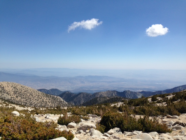
We were prepared for the hike with plenty of water and supplies. During our hikes, we had great weather, that even bordered on the edge of being too warm on one of our two hikes. For a majority of the hike we were rewarded with sweeping views of Southern California. One of the steepest portions of the hike to the top of Mt. San Gorgonio on the Vivian Creek Trail is in the first mile and a half after you cross the river near the beginning of the trailhead. The really steep portion ends once you reach Vivian Creek Camp. This is always one of the most difficult sections of the hike. If you want an idea of the current weather and conditions of the San Gorgonio Wilderness, click
Here for a live webcam of Mt. San Gorgonio courtesy of
BigBearWeather.com. During the summer months, always be on the watch for thunderstorms. June is usually a little early for the summer monsoon season, but anything can happen in this area. While on our hikes we had dark clouds that developed, but they never turned into thunderstorms.

Most of the year, there is plenty of water to filter along sections of the Vivian Creek Trail. However, during some summer and fall months, there may not be as much water in the springs/streams as compared to other years. Water information is provided by the San Gorgonio Wilderness Association. We filtered our water from the creek at high creek camp. It is always a great idea to bring your water filter with you on this hike. Everyone from our group would attest, the most deceptive part about this hike is the false summit that is present on the hike. Just remember when you appear to be getting near the summit, you have a little bit further than you think. Our entire group made the summit and spent about an hour at the top soaking in the views!
Rating: Elevation Gain: 5,600 ft. (Strenuous), Distance: 16 Miles Roundtrip (Strenuous), Note: be on the watch for Altitude sickness since the height of Mt. San Gorgonio is 11,502 ft.
Time to Complete Hike: 7.5 - 10 hours.
Good Training Hikes:
Mt. Baden-Powell,
Mt. San Jacinto,
Saddleback Mountain,
Cucamonga Peak,
Mt. Baldy.
MORE TRAIL WRITE-UPS ON MT. SAN GORGONIO


Comments
Post a Comment
Ashley and I encourage and welcome our readers to submit comments about their experiences on the trails we have posted on our blog or about their own hiking experiences in general.